Steps
1) Gather a group of 10 to 20 people. Let everyone introduce themselves. Give a brief introduction of the mapping activity. Lead a discussion to agree on symbols to use to mark various features. Example of symbols that can be used:
2) Draw an outline map of the catchment area on a blackboard or on the ground using chalk, charcoal or sticks indicating boundaries for use during the mapping exercise.
3) Divide the team into smaller groups of 3 to 5 people. Agree on the time to be taken for the mapping exercise. Agree on team leaders for presentation of team discussions.
4) Instruct each group to draw the outline map of the village indicating locations of households, social amenities i.e. roads, churches/mosques, schools, water points, health facilities, marketplace, council office. Etc.
5) Each group can conduct a transect walk to identify the location of key features and households in the area. This may be done by house to house visits.
6) After agreed time is completed. Each group leaders presents their maps. Following the presentations, facilitate a discussion to bring together all community resources and features into one single map on a large manila or Flipchart. Make sure the map is to scale as much as possible. Generate agreement on the map.
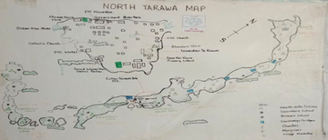
7) After all information has been consolidated into a single map and the participants agree to it, conclude by thanking the group for their contribution and provide information on how the health facility will use the map. See below example of a community map:

Average Rating: ☆ ☆ ☆ ☆ ☆ (0 reviews)


